 Border Crossing
Crossing the Thai-Laos border, from Ubon Ratchathani to Pakse, was a simple affair. The same bus took us the entire distance, letting us off at Chang Mek to depart Thailand at the Thai immigration office, and waiting on the Laos side while we walked to the Laotian immigration office and got our new visas. From there, we were driven to the VIP bus stop in Pakse (which is different from the regular bus station in Pakse, some eight kilometers farther east). Overall, the trip from Ubon to Pakse took about four hours.
From the VIP bus station, we headed to the regular bus station to catch a sawngtheaw to Ban Tat Fan on the Bolaven Plateau. Our transport to the regular bus station was a motorbike with a side-cart for two passengers.
Sawngtheaw Ride
As a reminder, a sawngtheaw is a small pickup truck with two bench seats mounted in the bed, and a roof over the top of the bed. The sides are open, with some trucks having canvas sides that can be dropped for rain.
It had been well over a month since we had last ridden a sawngtheaw, and this 38-kilometer ride was as fun and interesting as ever. Cargo was piled onto the roof, tied to the tail, and stacked in the center of the bed. Fifteen people were also stuffed into the truck, with two hanging off the tail. Two young boys fell asleep on their mother, who was also asleep; with the head of one of the boys ending up in Jen’s lap. A chicken also traveled with us, sitting very quietly between its owner’s feet.
Sawngtheaw’s are probably the best way to travel if you want to get the feel of a place. Northern Laos had little in the way of a sawngtheaw traffic system. Like northwestern Thailand, southern Laos appears to rely much more on these pickup-taxis.
Laos Redeemed?
Jen and I had left northern Laos well before our visas expired. We were suffering from Laos fatigue, having found the country’s north to be less than friendly. When we said “hello” to someone in the north, the response was often silence or a grunt. Restaurant staff tended to be indifferent, at best. It was usually a cold reception, particularly when compared to our previous experience in northern Thailand.
The main reason for returning to Laos was to see if things are different down south; if the people are warmer. So far, that has been the case. It has only been a handful of days, so it’s still too early to draw a general conclusion, but we are actually experiencing smiles and waves and “hello’s” – more on the Bolaven Plateau than in Champasak, but Champasak is still an improvement over the north.
It’s a very, very pleasant change.
 The Bolaven Plateau
The Bolaven Plateau is east of Pakse, at a noticeably higher, cooler, and wetter elevation (we broke out our fleece for the days we were here).
It’s coffee country, with plants growing on just about everyone’s land and yard. There is a large coffee factory under construction between Pakse and the plateau.
Jen and I speculated if this is a factor in the more-friendly nature of the locals. Where life in the north revolved around rice, life around here revolves around coffee. I am guessing here, but I imagine that the labor-per-pound and the profit-per-pound is higher with coffee than it is with rice, and I wouldn’t be surprised if the yield-per-acre is higher, too. A more leisurely and profitable lifestyle always makes for happier people.
In addition to coffee, the Bolaven Plateau has waterfalls. We visited three of them – Tat Fan, another waterfall about a mile north of Ban Tat Fan, and Tat Etu. Waterfalls are the primary tourist draw for the area.
For accommodations, we initially stopped at the Tad Fane Resort near the Tat Fan waterfall, just south of kilometer marker 38 on Highway 23. The Lonely Planet guide gave it a good review, but a look inside two of its musty, dark rooms sent us back to searching. We would have only stayed here if circumstances prevented any alternative, as Jen’s allergies would have exploded. As it was, we walked three miles in the rain, with heavy packs, to escape the place.
Our escape led us to the E-Tu Waterfall Resort (click here). This proved to be a decent place to stay – not perfect, but way ahead of the Tad Fane Resort. It is next to the Tat Etu waterfall, with concrete steps leading down to a foot bridge across the river at the base of the falls. It looks like there is swimming to be had in the dry season, when the water is lower and calmer.
A worthwhile restaurant operation we found is located in Ban Tat Fan, close to the intersection of Highway 23 (at kilometer marker 38) and the dirt road leading south to Tat Fan waterfall and the Tad Fane Resort (click here to read about the restaurant).
 Champasak
After a few days on the Bolaven Plateau, during which it rained considerably, we headed to Champasak. This small town sits on the west bank of the Mekong River, about thirty kilometers south of Pakse.
Unlike the Bolaven Plateau – less than 50 miles away as the crow flies – Champasak was hot, humid, and sunny.
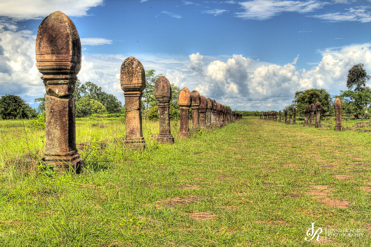
Champasak’s claim-to-fame is Wat Phao, the ruins of an ancient Khmer temple. The ruins lie just a few kilometers southwest of Champasak, and the town is the place to stay when visiting them.
The town of Champasak is small; with a potholed, almost-one-lane road running through it. There is a handful of guesthouses for visitors, and a single bank office with no ATM. We stayed here several days, and it was not a bad place to park for a while.
More on the guesthouses…
We stayed our first night at the Anouxa Guesthouse (click here). It was marginal at best, so we started looking for other accommodations.
One of the places we looked was Dokchampa Guesthouse. It gets some favorable comments in the Lonely Planet guide, but the guide is dead wrong. The place sucks. We would never stay there.
So, we went upscale to the Inthira Hotel (click here). Although pricey, this place is nice by most any standard. We were there for the remainder of our stay in Champasak.
More on the bank…
There is no ATM in Champasak. There is just a small branch of the Lao Development Bank, open Monday through Friday, closing at 3:30pm, and vacant for lunch. Unlike ATM withdrawals we have done elsewhere in Laos, where we have had no transaction fees, withdrawals using this branch involved a 3% transaction fee, plus a forty-kip spread on the buy and the sell. Tack on your own bank’s international transaction fee, and you are losing 4-1/2% or more on the deal. Lesson learned is to hit the ATM before heading to Champasak.
 More on the ruins…
As ruins go, I reckon these are pretty good – big, expansive, with a nice setting. Jen found them fairly photogenic, save for the other tourists that occasionally got in the way. But, on the plus side, the ruins were lightly touristed, and without an amusement-park-like character, as had been the case with Phanom Rung Historical Park in Thailand.
Some parts of the ruins are undergoing reconstruction right now, which blocks access to them and interferes with photographs. Other parts, however, have accessibility that would be unheard of for a similar archaeological site in the States, where you would be lucky to get within satellite range. We were able to stand inside what’s left of a 1500-year-old temple, with Jen photographing it, while a Laotian family made offerings and prayers to the Buddha statue, and rain water dripped on us from overhead vines. So, as ruins go, these are pretty good.
Just outside the entrance to Wat Phao, we found a decent place to eat, the Phimphone Restaurant (click here).
 Don Daeng
Don Daeng is an island in the middle the Mekong River, directly across from the town of Champasak. It takes about twenty minutes to get there by local boat. It’s about eight kilometers long, with a handful of small villages on it’s perimeter.
We read in the Lonely Planet guide that the inhabitants of Don Daeng were wary of tourism, not wanting to become another Vang Vieng. We had also read that there were no cars or trucks on the island – only bicycles and motorbikes and farm tractors. This interested us, so we headed over for an afternoon to check the place out, along with it’s accommodations, with an eye toward heading over for a few days.
We walked the northern tip of the island, including the village of Ban Hua Don Daeng. We only saw a fraction of the island, but it’s the fraction where the only two accommodations are located.
What we saw in Ban Hua Don Daeng, on the northwestern tip of the island, was a fairly quiet and standard rural village, save for pathways where there would otherwise be roadways. What we saw on the northeastern tip of the island was fairly quiet and standard rural farming.
 As to accommodations, there are three options. One is to flop on the floor of a building in the Community Center on the northern tip. This may not be as bad as it sounds, as the Community Center looks on its face to be a fairly squared away operation (it’s a handful of buildings in a fenced area, just north of Ban Hua Don Daeng). But no one was around to show us what might lurk behind the mask, so we can’t vouch for it. You have to make advance reservations to stay here.
The second option is a homestay with a local family. We happened to run into the head of one of the homestay families, who squeezed a pen out of me, pointed out his poverty in a manner that sounded much like a request for funds, and then tried to take a finders fee from the lady running the eatery operation we used. He had the advantage of speaking some English, no doubt the result of his homestay operation, and was abusing the power that came with it. Now, we are not saying that all homestays are run by this kinda guy, but it did turn us against the idea.
By the way, this guy lives in a house on the main drag running through Ban Hua Don Daeng, at the southern end of the village, on the west side of the road, directly across from the lady running a one-table eatery operation under her elevated house.
The third option for lodging is the new La Folie Lodge, located on the riverfront just south of Ban Hua Don Daeng. This is a resort-style operation, with restaurant and open-air dining in one structure, a swimming pool, and multiple guest room structures with two rooms to a structure (they’d call it a bungalow, but in our book, more than one accommodation to a building does not a bungalow make). It’s a pretty place, and pretty damned expensive. Beer was three times the going rate (always a good litmus test for pricing); the menu was priced in US dollars, with many dishes in the $20+ dollar range; and the rooms were $95 a night. That’s stupid expensive by Laotian standards.
So, accommodations weren’t stacking up so well.
As to dining, all we could find was the lady under the house, and the lodge’s restaurant with the $10 French fries.
So, Don Daeng wasn’t looking so promising. We took a boat back to Champasak, and scratched the island off our long-term stay list.
Illness
During our stay in Champasak, both of us struggled through a pretty mean cold – sore throat, headache, fatigue, snot, phlegm, and such. I didn’t know I was capable of producing that quantity of mucous. Roll after roll of toilet paper got chucked into the waste basket, one snot-soaked ball at a time.
Before leaving the States, we were given every vaccine produced by modern medicine, for every illness we might possibly contract, in every country we were even considering visiting. We carry a medical kit loaded with antibiotics, allergy medications, and a year’s supply of malaria prophylaxis. Rabies, anthrax, hepatitis a-z, Japanese encephalitis, yellow fever – it all means nothing to us. The common cold, however, kicked our asses.
…and Next
From here, we are headed to the 4000 Thousand Islands area of Laos, close to the Cambodian border. Once we get sick of that, we are into Cambodia for a time – that time defined by the date of September 1st. On that day, we have a flight from Bangkok to Perth, Australia; where we will start a 600-mile hike on Western Australia’s Bibbulman Track.


